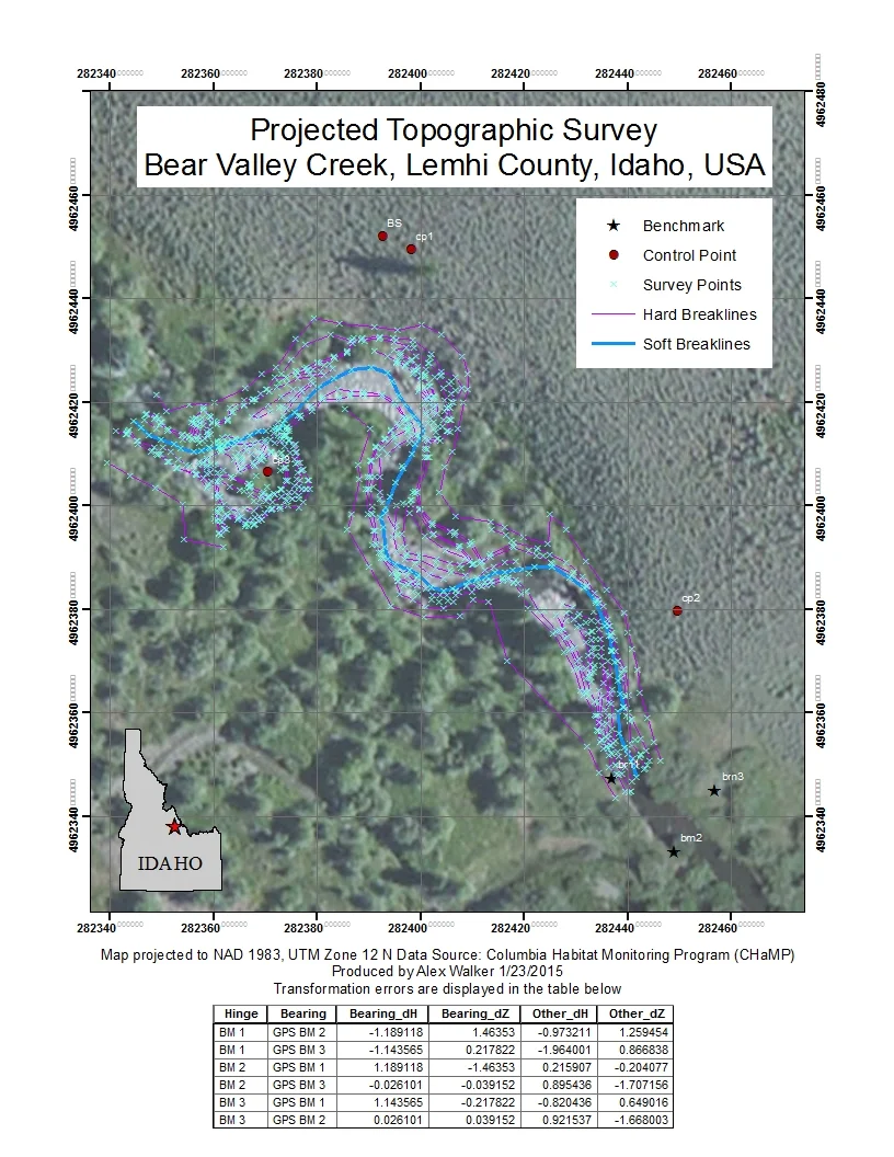
The purpose of Lab 2 was to give us practice in importing data that is unprotected and then projecting it to a coordinate system. This task gave us an idea of the process involved in projecting data in ArcGIS as well as the uncertainty involved in projecting data. For the transformation of data, we used the CHaMP Transformation Tool, an ArcGIS AddIn developed by the Columbia Habitat Monitoring Program (CHaMP). A full rundown of this lab is available on the course website here.
Task 1
The goal of Task 1 was to plot up unprojected data in an empty ArcMap document. Once the data was plotted, I overlaid it with a grid in an assumed Cartesian coordinate system. Adding the grid shows that the points, while not having a coordinate system, does have scale. I finished this plot with appropriate symbology and titles for the data being displayed.
Task 2
In this task, I transformed the data from the assumed Cartesian coordinate system in Task 1 into a projected coordinate system via CHaMP Transformation Tool, choosing the best available parameters based upon both visual inspection of the data and minimization of residual errors. The coordinate system used was the North American Datum of 1983, UTM Zone 12 North. Many other transformation tools are available in ArcGIS, but the affine transformation used by the CHaMP Transformation Tool is suitable for our purposes due to the high variability (+/- 5 m) in collected data. The high variability is because points were collected by a handheld GPS with a low degree of precision. In our case, the ability of an affine transformation to rotate and translate data, coupled with the fact that the largest precision issues are in the data set, is the reason why it makes sense in this case.
Maps for Task 1 and Task 2 are shown below, with unprojected data on the left and transformed data on the right. Transformation errors are shown in a table underneath the projected topographic survey on the right. The table shows errors for every possible hinge and bearing avaiable between the three benchmarks. For my transformation, I chose BM 2 as the hinge with the GPS point collected at BM 3 as the bearing.
For high resolution PDF downloads, please click the links below.
Unprojected Topographic Survey, Bear Valley Creek, Lemhi County, ID
Projected Topographic Survey, Bear Valley Creek, Lemhi County, ID
Task 3
For the final task, we were asked to publish our data into an interactive web map. For this I used the My Maps function in Google Maps. As of 1/23/2015, there are some serious functionality issues with this function in Google Maps. The two largest issues are that it cannot currently handle KMZ files and does not preserve symbology contained in KML layers when uploaded to the web application. A further issue is once data is uploaded, you can't edit the size of the points. It does work, but appears to still be an advanced beta phase.
Manually performing transformations is more tedious than letting ArcMap automatically reproject data, but it is necessary for when the data has no system at all. The information must be projected in order for GIS overlay and analysis to be performed. Additionally, actively reprojecting the data allows for greater control of the coordinate system used and in the case of the affine transformation discussed above, a user can define the benchmark along with the bearing used for rotation and translation.
Further Information
Lab 02 - Coordinate Data, Projections & Transformations
References
Joe Wheaton & Shannon Belmont. Lab 02 - Coordinate Data, Projections & Transformations. 2014. gis.joewheaton.org Web. 23 January 2015 http://gis.joewheaton.org/assignments/labs/lab-02---coordinate-data-projections-transformations
Joe Wheaton. Download Tool. 2011. ctt.joewheaton.org. Web. 23 January 2015. http://ctt.joewheaton.org/home/download-tool
